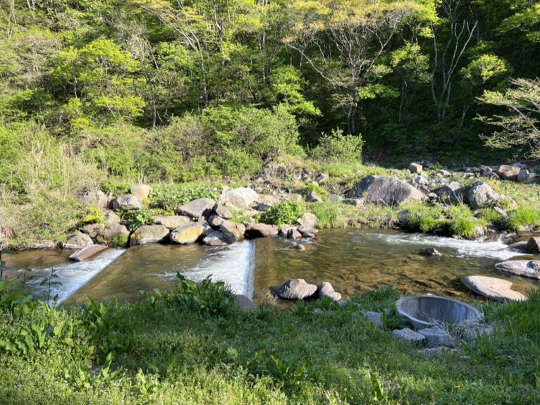
One place on the Michinoku Coastal Trail hikers should get ready for is the Koge River wading point, which is at the border between Hirono Town and Kuji City in Iwate Prefecture (see Hiking Map Book 1-8). The river is normally about 3 meters wide and split into two with a rocky sandbar in the middle (no sandbar and a single flow further upstream?). This is an adventurous point with no bridge or stepping stones to get across, so hikers who decide to cross here are going to need to get in and wade to get across. Please keep this in mind: there is no way to get across without wading through.
(The photo below shows the relatively calm Kouge River, with the water level at about knee-high.)

”What is Koge River’s water level today?”
We sometimes receive such inquiries at the Natori Trail Center, but unfortunately we are unable to answer as we do not know the daily conditions at the site. We have no choice but to make a judgment based on the actual conditions at the site, taking into account the rain conditions from the past few days. Also, in spring, the water level may increase daily due to melting snow upstream.
Be especially careful! During the spring thaw and for a few days after heavy rain!
Whether or not you can cross should be judged based on your own experience and physical strength, the local water level, and the force of the current.
If you give up on crossing and decide to take a detour, you will have to backtrack and make a large detour, and especially if you have walked north and are making a detour, you will have to climb a steep slope again, so you may feel like forcing yourself to cross.
Even so, never attempt a crossing that is too difficult. Even if you start to cross, if you think it is too difficult, have the courage to turn back. Fatal accidents have actually occurred while crossing both in Japan and overseas.
Click here for information on detours.
Where should I cross?
If you’re heading south, there’s a counter for hikers set up near where you arrive at Koge River. (First press that counter once so we can count you!) I tend to cross right where that counter is, but some hikers report that if you go a little further upstream from there, there’s a point where the river is calmer.
In any case, your feet are going to get wet, and whether you’re going north or south, you will need to see for yourself and use your judgment on where/whether you can cross.
How to cross
There is no “surefire” or “safe” way to cross a river. Different people and groups will recommend different methods. Please remember that most of the advice, other than the safety measures using ropes and equipment, is based on past experience.
It is difficult to judge distances underwater, and even if the water looks shallow, it may actually be deep. It is said that it is best to walk by taking small steps and tiptoeing to find your footing. There are various methods for doing this. There is no set way, but some suggest facing your body slightly upstream, walking like a crab, or moving diagonally from upstream to downstream.
This is because the flow of water in a natural river is not constant, but changes. When there is a flood, the riverbed itself changes, and the flow becomes like a different river, and there are natural changes that are unique to rivers. How you walk can only be judged by yourself at the time, and there is no recommendation that can be made without being at the site.
□ The Koge River is wide, so it is best to assume that it is generally not possible to cross it using stepping stones. Even if it is possible, there are many cases where people lose their balance or slip on loose stones, falling and getting injured. Even if it is a small crossing, it is safer to get in the water and not be afraid to get wet.
□ Do not walk barefoot. This increases the risk of injuring your feet. Also, do not wear sandals. They are more likely to encounter resistance in the water and make it easier for your feet to get swept away. We recommend crossing with shoes that allow water to drain easily.
□ Trekking poles or other walking sticks are useful for feeling underwater and stabilizing your position when crossing a river.
□ If you fall or are swept away while wearing a backpack, the buoyancy of the backpack may cause you to fall face down and you may drown. Remove the buckles on your chest and waist so that you can quickly remove your backpack if you fall in the river.
〜〜〜〜〜〜〜〜〜〜〜〜〜〜〜〜〜〜〜〜〜〜〜〜〜〜〜〜〜〜〜〜〜〜〜〜〜〜〜
The crossing of the Koge River was incorporated into the route due to the wishes of the late Noriyoshi Kato, a proponent of the Michinoku Coastal Trail, who continued to advocate the importance of being in touch with nature and worked hard to popularize long trails as a place to put this into practice.
If you start walking from the north, the Koge River marks the entrance to a physically challenging section of the trail, and if you start from the south, it serves as the exit.
Remember, never try to cross if you don’t feel good about it. And when you think “let’s do it!” and want to just go for it, that is exactly when you should stop, keep cool and think logically about what to do. Have fun and above all, please be safe.
